Tuesday, April 27, 2010

4-12 through 4-19-10 Cusco, Peru and Lares Valley to Machu Picchu trek (1st 5 pics taken in Cusco then Lares Valley trek to Machu Picchu)


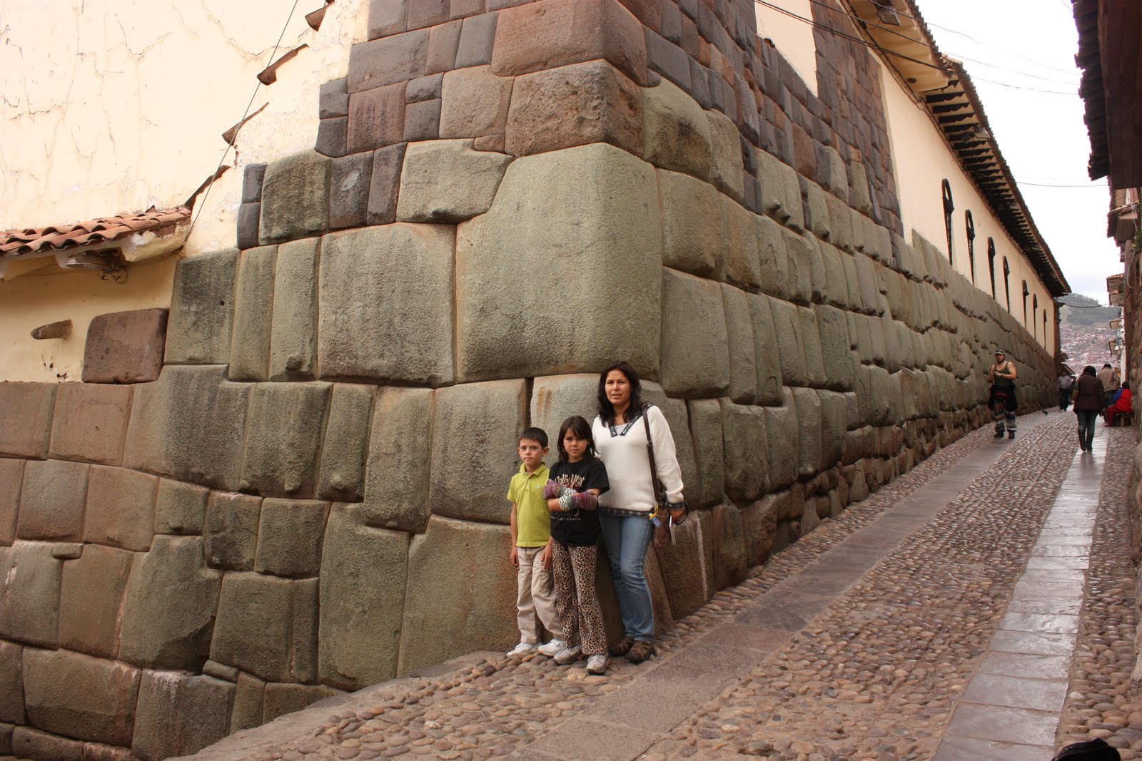
4-12 through 4-19-2010: We arrived in Cusco; a lovely, albeit, touristy city at an altitude of 11,200 feet. It had lots of plazas with fountains, lots of old churches, and remnants of Inca walls downtown.

On 4-12, we visited the Museo Inka which has the best collection of Inca artifacts in Cussco. It also gave a good background on Andean environment and history: the casa of antepasados (house of the ancestors) was interesting. Mummies were housed behind a display that had glass windows looking into the ‘house’ as well as eerie red lighting. We also saw indigenous people weaving textiles by hand using a wooden loom and an artist that crafted small sculptures and other objects using granite stone from the Machu Picchu area. One sculpture we liked especially showed the 3 worlds of the Inca; the condor which represented the spirit or future world, the puma which represented the present or physical world, and the serpent which represented the past or underworld.

FYI: Cusco has been continuously occupied for at least 2000 years and claims to be the oldest city in the Americas. Cusco has an altitude of 11,150 ft and is surrounded by even higher mountains. The Incas constructed the city in the shape of a giant puma.

(4-13 through 4-16-10) On 4-13, the family began a 4 day/3 night Lares Valley trek with a final destination of Machu Picchu. A private car drove us from Cusco, through Urubamba, Calca, and to Lares where we soaked in mineral hot springs and had lunch before beginning our hike. We hiked 8 km in 3-1/2 hours with a 1600 foot climb to our 1st camp at Huacahuasi.

The next day (day 2) we ascended 2000 ft to cross Paso Ipsaycocha (Ipsaycocha Pass) at an altitude of 14,400 feet (our highest point of the trek) then descended 2000 feet to our 2nd camp at Patacancha (the hike was 12 km and about 5-1/2 hrs). Our guide, Henri, had advised us before starting our trek to buy a couple packages of pencils since the indigenous kids flocked to the trail hoping to get ‘caramelos’ (candy) from the passing tourists, but pencils were a better option and more practical.

Day 3 involved a 5 hr, 12 km descent to the town of Ollantaytambo where we took a 1-1/2 hr train ride to the town of Aguas Caliente (town outside of Machu Picchu).
The next morning (day 4) a guide gave us an informative 2-1/2 hr tour in Spanish. We spent additional time exploring the ruins and walking to the Inca drawbridge; the trail hugged the cliffside with steep drop-offs. Luckily, the drop-offs were obscured by clouds (the weather was rainy and cloudy) and vegetation so the fear of heights factor wasn’t a problem. The architectural techniques and building designs of the Incas was spectacular.

Machu Picchu Facts: It is situated in the highland jungle at an altitude of 2432m (7972 feet). Th most common stone found in the region is grayish-white granite which contains high quantities of quartz, mica, and feldspar thus making it relatively easy to shape. Therefore, the rock was a magnificent building material for the Inca masons.

4-18-10: The family walked around Cusco looking at remnants of Inca walls, the architecture of colonial churches/cathedrals, remains of an Inca temple (Koricancha), and the polygonal stone walls of Hatunrumiyoc’s palace which has the famous 12-angled stone. In the neighborhood of San Blas, we stumbled upon the Museo de la Coca; a small, private museum dedicated to promoting knowledge and understanding of the Inca’s sacred leaf. We saw an interesting chart listing the numerous vitamins and minerals coca has along with its medicinal properties. Its use was also interwoven in all facets of the Inca lifestyle and its use and importance continues in the present day indigenous descendants of the Incas.

Saturday, April 17, 2010

3-29 through 4-11-10- Our stay in Sucre, Bolivia ends


4-2 through 4-4-10: Our last 2 weeks in Sucre were relatively uneventful; the highlight was a trip into the mountains outside of Sucre to Aritumayu Ecolodge. A lodge employee picked us up in an old Toyota Land Cruiser. The road to the lodge was very bad secondary to erosion but it led to a beautiful lodge with lots of trees that the owner had planted 20 years ago to help reforest the area. The lodge didn't have electricity so we used headlamps, candles or kerosene lamps at night. We hiked to an aqueduct built in the 1900s that still carried water to Sucre (via a pipe currently instead of the water running along the top). Aritumayu is Quechua for 'closed river' due to the secluded nature of the area where a river runs through the property.

We took a short horseback ride around the mountains and took in the beauty of the canyons and waterfalls. The kids enjoyed riding and hanging out with the horses; the horses were able to freely graze on the lodge property but the owner (Don Jose) would shoot small rocks at them with his slingshot if he saw them munching from the flower garden area.

Since we were at the lodge Easter weekend, Mike and I brought up foil-wrapped chocolate candies for an improvised Easter egg hunt in the flower garden. We left late Sunday around 7 p.m. to return to Sucre. There was a restriction on car traffic in Sucre until after 6 p.m. due to voting for the city elections (having them on Easter Sunday didn't make sense).

4-9-10: Mike and the kids finished their studies at Bolivian Spanish School and they received certificates. Everyone was sad to say goodbye.

4-10-10: We sadly bid goodbye to our landlady and friend Rosita and her dear dog Spot and hopped on an overnight bus heading to La Paz, Bolivia. La Paz is located at an elevation of 3,660 meters making it the world's highest capital city. The city sits in a "bowl" surrounded by the high mountains of the altiplano. As it grows, La Paz climbs the hills, resulting in varying elevations from 3,000 meters to 4,100 meters (9,840 ft to 13,450 ft). Overlooking the city is towering, triple-peaked Illimani which is always snow-covered and can be seen from several spots of the city.

We found lodging in La Paz the next morning upon arriving, rested, then headed out to explore the town of Tiwanaku and its Pre-Colombian archaeological site of the same name (75 km outside of La Paz). Tiwanaku is recognized by Andean scholars as one of the most important precursors to the Inca Empire, flourishing as the ritual and administrative capital of a major state power for approximately 500 years. We enjoyed touring the on-site museums and marveling at the ruins and stone statues. We saw areas that were actively being surveyed for future excavation.

4-11-10: We took a plane out of La Paz this morning headed for Cusco, Peru. It was a short 1-1/2 hour flight; it beat taking the bus for 17+ hours. The La Paz airport is the highest airport in the world with an altitude of 13,323 feet. Tibet in the Republic of China has the two highest airfields in the world; Bangda airport (15,548 feet) and Lhasa airport (14,315 feet). Mike noticed that the runway was very long (2.5 miles actually) and that the plane took much longer than usual to achieve lift-off due to the low air pressure at this elevation.

Monday, April 12, 2010

3-21 through 3-28-10 Pujllay festival in Tarabuco, Bolivia


3-21-10: The Pujllay is a traditional celebration that occurs annually every March to remember the Battle of Jumbati. This crucial battle took place on March 12, 1816, 50 kilometers outside of the city of Sucre. Indigenous soldiers, led by indigenous leaders, overcame the Spanish during the fight for independence. The festival takes place in the town of Tarabuco, not far from the battle site. The souls of the soldiers who died in the battle are honored.

Another part of the Pujllay celebration involves the Pucara which is a magical-religious symbol in the form of a large ladder which is decorated with flowers, fruits, drinks, and agricultural products of the region. It is erected in an open area as an offering to the deceased and groups of indigenous dancers dressed in colorful, traditional costumes dance around the Pucara.

The Tarabucan people often wear leather hats called “monteras” that are fashioned after the helmets of the Spanish conquistadors. During the Pujllay, this hat is adorned with flowers (sometimes made of cloth). The attire of both male and female dancers is quite elaborate. The men wear platform sandals called “ojotas” that have large decorative spurs attached. The sound of the spurs, as well as the sound of the bells attached to broad belts worn around the waist, contributes to the music produced by wind instruments, the toqoros, senq’as and wajras.

3-26-10: Gaby and Luke have been participating in late afternoon workshops Mon.-Fri. for 2 weeks now to increase their interaction with Bolivian children. Although they resisted initially, they have been enjoying the different workshops and have been conversing with their teacher and the other kids in Spanish. Their teacher is from France and her Spanish has a strong French accent but it doesn’t seem to be a problem for the kids in her classes. The workshops include math and word games, art class, as well as board and team games.